

Cyclonic storm ‘Dana’ in severe form, will hit the Odisha coast late night
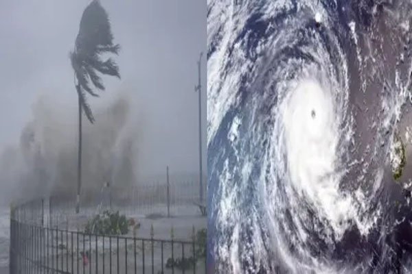
Bhubaneshwar| Cyclonic storm Dana, which developed in the east-central Bay of Bengal, has intensified into a ‘severe’ cyclonic storm. It is likely to reach Odisha coast between Bhitarkanika and Dhamra in Bhadrak district late at night.
“Cyclonic storm ‘Dana’ over east-central and adjoining west-central Bay of Bengal moved north-northwestwards at a speed of 15 kmph during the last six hours and intensified into a severe cyclonic storm over central and adjoining north-west Bay of Bengal”, the Indian Meteorological Department (IMD) said.

It is very likely to move northwestwards, crossing the coasts of Odisha and West Bengal as a severe cyclonic storm between Puri and Sagar Island, close to Bhitarkanika and Dhamra, between midnight on 24 October and early morning on 25 October. Its wind speed will be 100-110 km/h, which can reach 120 km/h in gusts.
Meanwhile, coastal districts like Jagatsinghpur, Puri, Kendrapara, Bhadrak and Balasore have been receiving rain since Wednesday evening due to the impact of Cyclone Dana moving rapidly towards the Odisha coast. The wind speed is continuously increasing at these places.

Manorama Mohanty, director of IMD in Bhubaneswar, told media persons on Thursday that Paradip received the highest rainfall of 51 mm in the last 24 hours due to Cyclone Dana, while Chandbali region received 39 mm. He also said that the cyclonic storm will hit the coast at midnight on Thursday and the process will continue till Friday morning.
Chief Minister Mohan Charan Majhi had already said that till Wednesday evening, around three lakh people have been evacuated from sensitive areas of the affected districts. The state government had set a target of transporting around 1 million people from sensitive areas to safe places, cyclone shelters and relief centers. He had assured that the evacuation process would be completed by afternoon. The state government has created about six thousand relief centers and cyclone shelters.